Continued from the last post that covered Days 01 to 09; Part 2 here covers Days 10 to 21!
Day 10 (Daocheng to Litang)
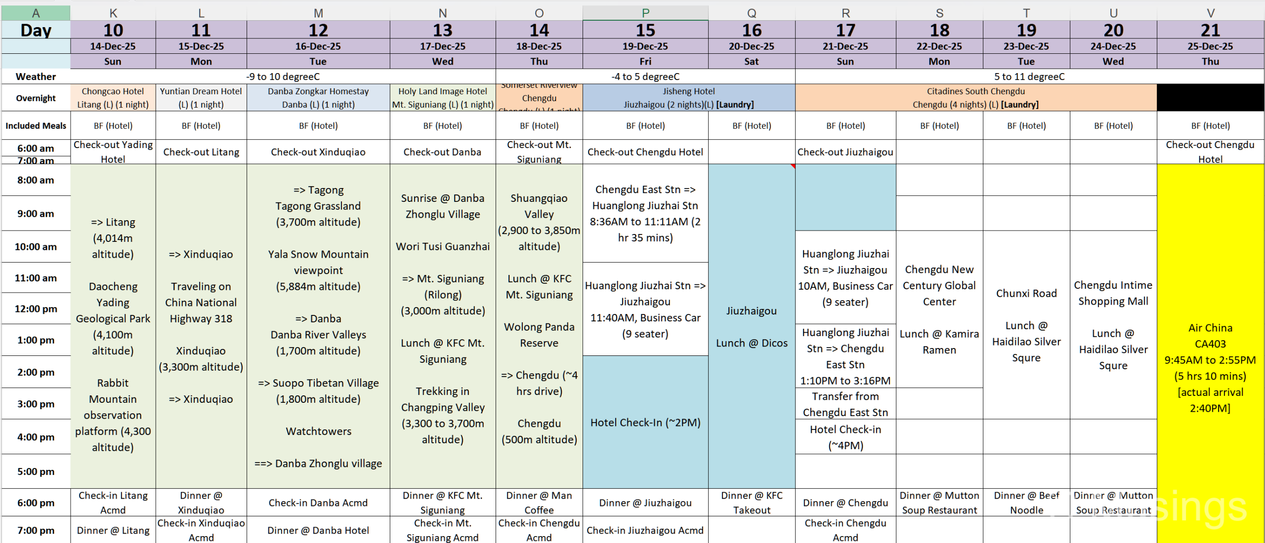
Daocheng Yading Geological Park (~1 hr) [blog post here]: we’d initially planned to visit Yading Nature Reserve for a second day, but dropped it as the wife was experiencing the effects of altitude sickness. Our original plan was to make it to Litang by the end of the day, so our guide let us have a late morning check-out, after which we continued our drive towards Litang and stopped on the way at two places. The Yading Geological Park is at altitude 4,100m and where the plateau areas are: a pretty desolate area in general, but there are several lakes that we checked out. They were frozen over, but the boy certainly had a ball of a time playing on the frozen lake, and I got some decent aerial videos of the area too. Still: if you’re not already passing by, it’s not worth it to detour to visit this spot.
Rabbit Mountain (~0.5 hrs) [blog post here]: a strange and funky-looking rock formation in the far distance. Yep, that’s it. The actual distance from the viewing platform and those rabbit ears is a lot further than it looks: I attempted to fly the drone to get a closer look at those ears, but the drone was only able to cover 2km or so before it already hit 50% battery levels: no doubt affected by the strong winds and 4,300m altitude. So, again, unless you’re passing by, don’t go out of your way to see this place.
Day 11 (Daocheng to Litang)
China National Highway 318 (all day) [blog post here]: this was a long but scenic drive, and there are plenty of places where you can likely stop the vehicle to soak in the sights. The various spots we stopped at for a look are lost on us though.
Balang Snow Mountain Viewpoint (~1 hr) [blog post here]: The drive along Xinduqiao town is easy, but the road that leads up to this viewpoint was pretty bumpy: though credit again to our local driver for taking it slow and making sure the drive up the mountain was as comfortable as the vehicle could manage. The treat up top is that you get to a viewing area with an uninterrupted view of Balang Snow Mountain (albeit in the distance), and also opportunities to take fun pictures where it can look like you’re flying in the air. LOL.
Day 12 (Litang to Danba)
Tagong Grassland (~1 hr) [blog post here]: vast plains for domesticated horses and cattle to roam and graze. Though in winter, you’re looking at large brownish lawns, so not particularly exciting.
Yala Snow Mountain Viewpoint (~0.5 hrs) [blog post here]: we didn’t go up close to the mountain either, as at this point we were already pretty saturated with snow mountain peaks. But the brief stop we made for a look at this mountain — albeit again in the far distance — was OK.
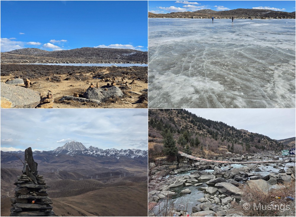
Danba River Valley and Suopo Tibetan Watchtowers (~2 hrs) [blog post here]: this was a lovely township in a canyon, and the area was still enjoying some late autumn colours. Very alpine-like, and the watchtowers reminded me of the “Lighting of the Beacons” scene in LOTR: The Return of the King where Pippin lights the first signal fire in Minas Tirith, initiating a chain reaction across the White Mountains to summon aid from Rohan. OK, the watchtowers are in a built-up area unlike as depicted in the film, but the way they are arranged really tells you how people of old passed messages quickly across distances. The drive up the hillside to reach our accommodation was less fun though: lots of winding and sharp turns — take your motion sickness pills!
Day 13 (Danba to Mt. Siguniang)
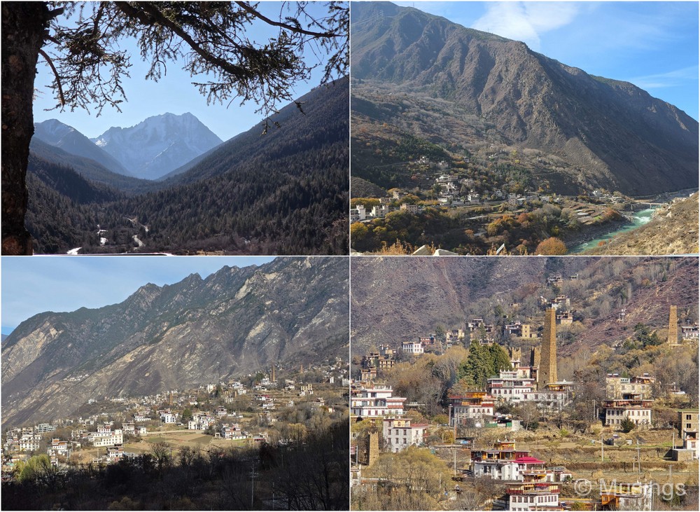
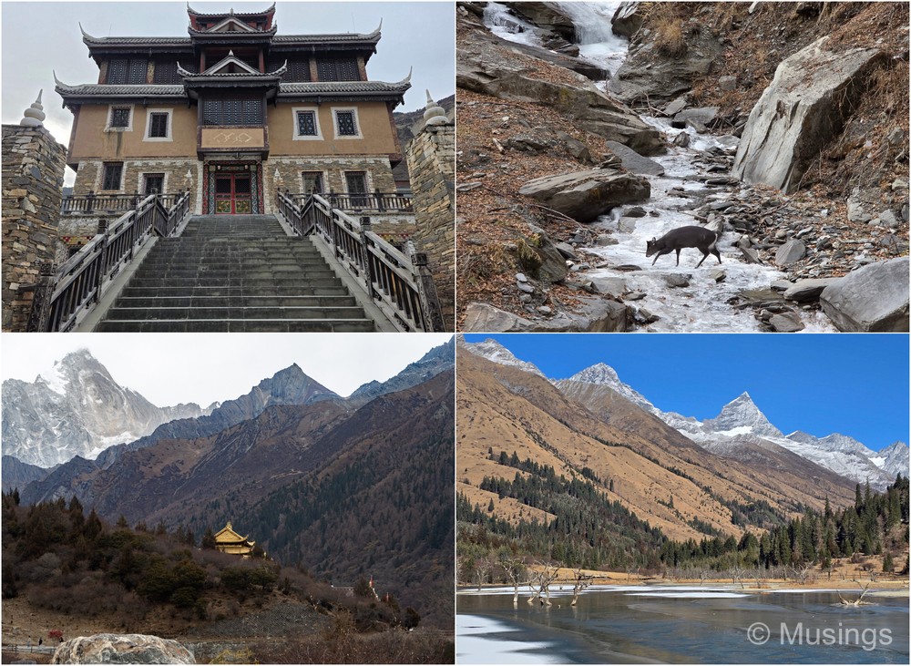
Wori Tusi Guanzhai (~0.5 hrs) [blog post here]: a quick stopover to check out a well-preserved small castle and accompanying watchtower as this was along the way to Mt. Siguniang, but quite skippable if you’re short of time.
Changping Valley (~2–3 hrs) [blog post here]: a trek that’s not too different from Yading Nature Reserve, though this time for us the trek was to visit one of the nearer waterfalls — Chongchongqiao Waterfall, which unfortunately had almost completely frozen over. The walk involves a fairly steep climb up steps that is exhausting, but all of us except the daughter managed it. Pro-tip #18: take your mountain shots and aerial videos here, as the other valley — Shuangqiao Valley — is a lot more crowded!
Day 14 (Mt. Siguniang)
Shuangqiao Valley (~3 to 4 hrs) [blog post here]: this is a pretty large valley with several points of interest that you get to via an internal shuttle bus. The spots point to point are not walkable in cold weather. Segments of the park were also already blanketed in snow, and this was considered fairly early winter in the country anyway! Altitude by this point for us was less of an issue, and the fact that we didn’t have to walk from place to place helped loads. This was also where the DJI Mini 4 Pro was lost, so Pro-tip #19: watch your corners if you’re flying. I thought I was on a safe flying pattern, but on the flight in the second area when the drone was returning, there was an, apparently, blind spot where it hit a tall tree and got stuck. RIP DJI Mini 4 Pro, May 2024 to Dec 2025.
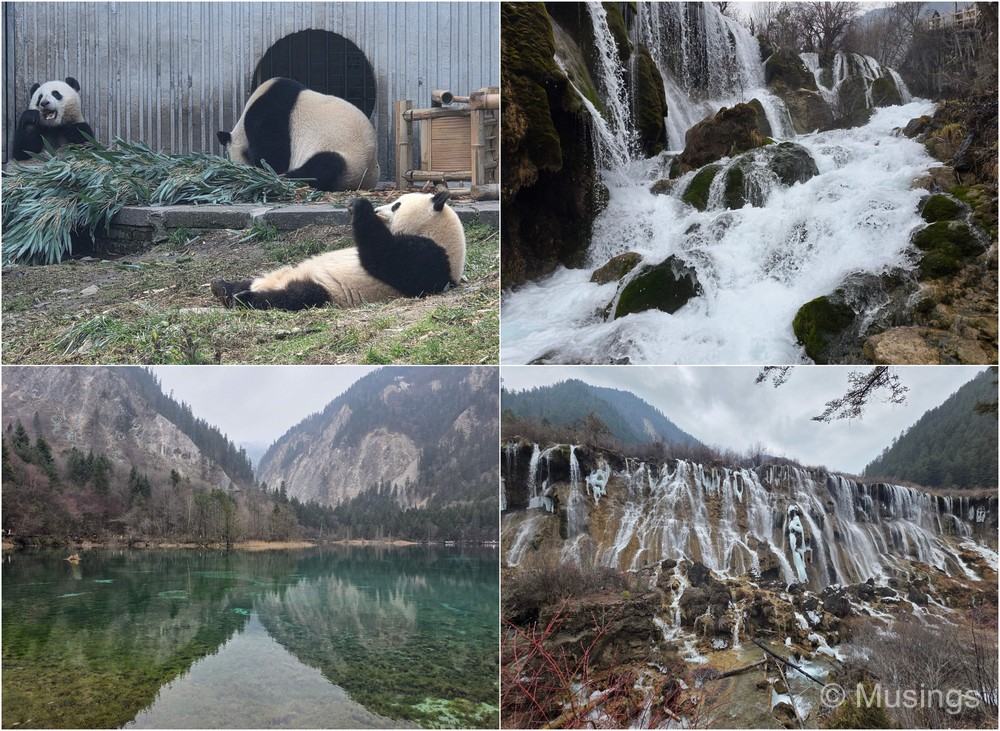
Wolong Panda Reserve (~2 hrs) [blog post here]: if you’re on the same route as we were, try to divert if you can to visit this panda reserve. It was, for us in the late PM visit, free of crowds, and there were just a handful of visitors besides us. A fair number of pandas were about munching away to the delight of the visitors who were present.
Days 15 to 17 (Jiuzhaigou Valley National Park)
Jiuzhaigou Valley National Park (whole day) [blog post here]: nothing more beyond what has already been said about the sheer beauty of this place needs to be said: the hype is true in real life for once: the stunning turquoise and mirror-like lakes and the cascading waterfalls. But so are the crowds: this was low season, but it already felt very busy. Thankfully, the internal bus service within the park works well and you can get from point to point without much walking, and the further in you are, the crowds thin out more and become bearable. Pro-tip #20: still, be prepared for walking even with the bus service, but the walking doesn’t involve steep inclines or a lot of up-steps for the most part. Also, plan in advance the spots you want to check out, as winter months mean iced-over lakes, and depending on whether the sun is out or ducking under cover, the visual experience can really differ. We visited in winter and on a very cloudy day, so we probably only got a small fraction of the real visual treat, amazing as it already was. Some folks visit this area as a day trip only: I honestly think you need at least 2 nights here, since it offers you one full day to cover both forks of the Y-shaped valley. But if you’re visiting in winter and crunched for time, I reckon you can indeed do this as a 2D1N, and be strategic about the places that won’t look good in winter.
Days 18 to 20 (Chengdu)
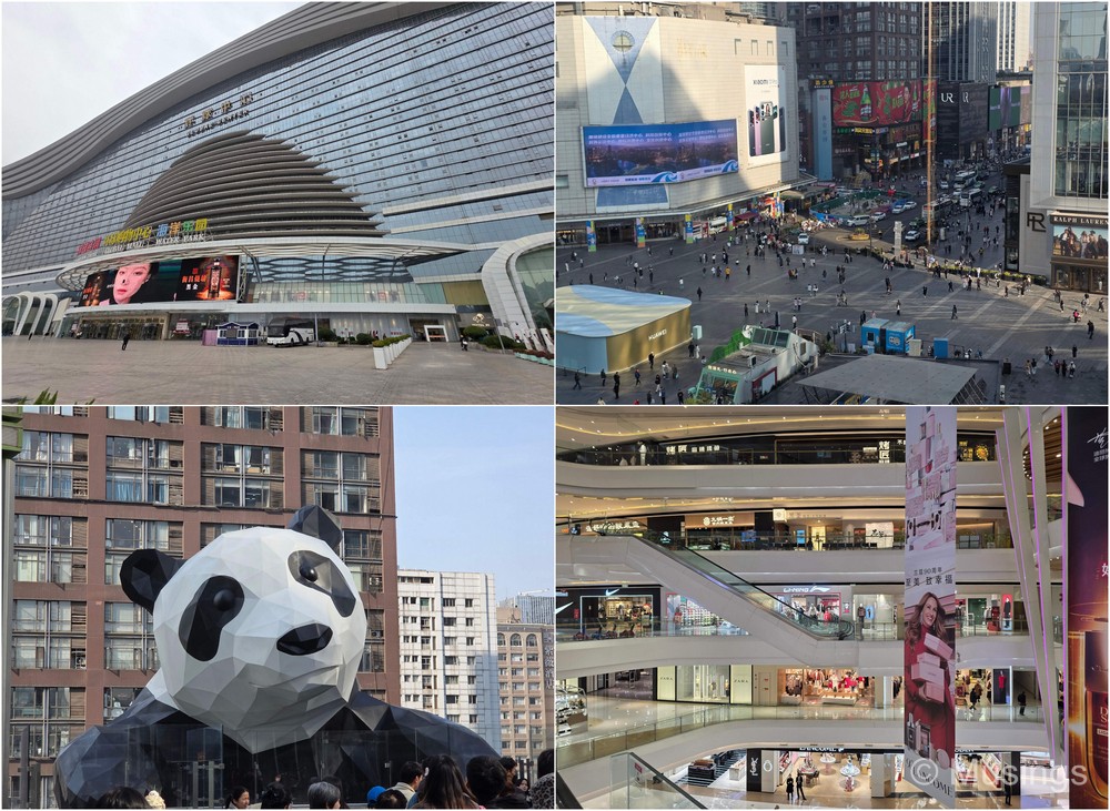
Chengdu [blog post here, here and here]: we kept our activities very light on the last three full days we had in Chengdu, and visited only the built-up sites and stayed indoors as much as we could. No, the weather was a lot warmer in Chengdu this week than in Shangri-La last week, but we were pretty worn out by this point! Of the several areas we visited, Chunxi Road and the Chengdu New Century Global Center area are probably the places most tourists would visit. You can easily spend a day (at least) exploring Chunxi Road if shopping is your thing, and the Global Center is also worth checking out for its sheer size and awesomeness, though the mall segment itself is just one part of the larger area.
Day 21 (Chengdu – Singapore)
Returning home [blog post here]: Our flight home!
>>>
Next, like always, we take the list of places we visited in the trip and categorise them into ‘Must See’, ‘Should See’, and ‘Add only as Filler’:
| Category | Places |
|---|---|
| Must see/visit | Tie-dyeing in Zhoucheng, Shuanglang Ancient Town, Dali Ancient Town, Black Dragon Pool, Lijiang Ancient Town, Spruce Meadow, Blue Moon Valley/Baishui River, Glacier Park, Tiger Leaping Gorge, Dukezong Ancient Town, Balagezong Echo Wall Glass Skywalk, Balagezong Grand Canyon, First Bend of Jinsha River, Luorong Pasture (Yading Nature Reserve), Danba River Valleys, Suopo Tibetan Watchtowers, Changping Valley (Mt. Siguniang), Shuangqiao Valley (Mt. Siguniang), Wolong Panda Reserve, Jiuzhaigou, Chunxi Road. |
| Should see | Xizhou Ancient Town, Little Putuo, Guishan Hill, Napa Lake (Horse-riding), Pudacuo National Park, Balagezong Village, Chonggu Temple (Yading Nature Reserve), Daocheng Yading Geological Park, Rabbit Mountain Viewpoint, Balang Snow Mountain Viewpoint, Yala Snow Mountain Viewpoint, Wori Tusi Guanzhai, Chengdu New Century Global Center, Chengdu Intime Shopping Mall. |
| Add only as Filler | Li Xiang Bang, Yuhu Village, Dragon Maiden Lake, Zhongyi Market, Zhuomalakang Monastery. |
That’s it for our itinerary and visitation notes. Next post: posting the wife’s (many) pictures of flora in China!